
Mountains in Uganda are some of the most beautiful in the world. From the equatorial glaciers on the Rwenzori peaks to the dry volcanic ranges in the semiarid Karamoja region in the north east. In this travel guide, find mountains that are ideal for both inexperienced and keen mountaineers and suitable top trekking travel offers.
These mountain parks are found in rural communities where people are mostly farmers. They’re some of the rich well-cultivated regions. You have the opportunity to visit their banana, coffee, and tea plantations.
Major mountains in Uganda
There are 8 major mountains in Uganda including Mount Rwenzori 5,109m, 3 Virunga Volcanoes which include (Mt. Gahinga 3,473 m, Mt. Sabinyo 3,669 m, and Mount Muhabura 4127 m), Mount Elgon 4,321 m, Mount Moroto 3,083 m, Mount Kadam (3,063 m), and Mount Morungole 2,149 m.
Mount Rwenzori ( The Mountains of the Moon)
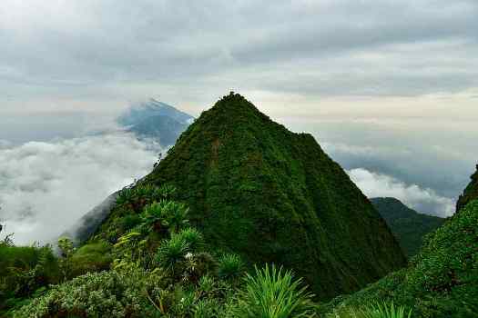
Rwenzori is the tallest mountain in Uganda. Mount Stanley’s Margherita peak elevation 5,109 m is the 3rd highest in Africa. The block mountain has six steep and rugged peaks separated by deep ridges and valleys including peat bogs at 4,500m. As such, trekking Rwenzori is challenging for even the most experienced climbers than it is to hike Mount Kilimanjaro. What makes it one of the best mountains in Uganda is that 3 of the Rwenzori peaks are covered by permanent snow. You will start to walk on glaciers as soon you reach Mt. Baker 4,844 m and Mt. Speke 4,890 m. The bigger equatorial glaciers are found on Margherita.
Sadly, the Rwenzori glaciers are known to be receding on the peaks of Baker and Speke. Klaus Thyman, an award-winning Danish photographer claimed during his mountaineering expeditions, first in 2012 and again in 2020. Climate change and unsustainable agriculture practices are some of the reasons for a change. Visit Rwenzori equatorial glaciers while they’re still visible!
Trekking Rwenzori along the Kilembe trail: So beautiful!
For keen photographers, Kilembe is the most beautiful trail when trekking Mount Rwenzori. The trail starts from the banana plantations and crops and winds through waterfalls in jungle, glacial lakes such as Kitandara. In the montane forest, you may spot chimpanzees, Rwenzori duiker, colobus monkey.
Truly, the path in the jungle is humid. There are wet meadows in the sub-alpine cloud forest vegetation. The second camp at Kalalama Camp is often skipped by experienced trekkers. Further, trekking towards Mutinda Camp (second night) in the Afro-alpine zone with deep valleys and mountains. Walk amidst the beautiful tree heathers and gardens of giant Senecios.
Walking from Mutinda to Bugata Camp, there are deep mud bogs at 4,040 meters above sea level you must walk through towards Weismann’s Peak. Indeed, trekking gets more tough with a view of Mount Stanley with it’s glacier.
Reaching the summit of Mount Stanley
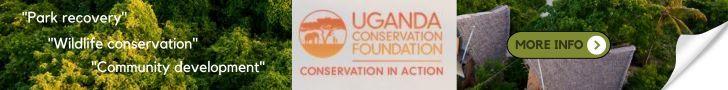
The final ascent from Bugata camp via Bamwanjara pass to Butawu Camp is the most challenging part when trekking towards Mount Stanley. More so, Butawu camp is the windiest and coldest camp along Kilembe trail on Rwenzori Mountains. Tucked between the rocky peaks of Mt. Stanley and Mt. Baker is the beautiful Lake Kitandara valley with giant lobelias and groundsels 4,250 m a.s.l.
On the Summit Margherita
Next, you will be walking over bare rocks and on equatorial glaciers. Finally, approaching the summit of Margherita Peak, 5109 m a.s.l., the highest point of the Rwenzori Range!
Climbing Mount Rwenzori can be completed in 8 days or less. For experienced climbers, it is possible to skip some of the camps. The high-altitude trek to reach the summit requires use of crampons, ice axe, head lights, and ropes. The final ascent begins before dawn.
Trekking mountains in Uganda with village walks
A cultural experience as part of their Rwenzori trekking tour is available in Ruboni community. You can visit a homestead learn how they prepare local food or a traditional healer for his stunning metaphysics.
Coffee tours on the slopes of Mount Elgon in eastern Uganda.
In addition, explore the shorter trails in the tropical forests with a chance to spot wild chimpanzees along Kinyampanika trail. For instance, 1 day Rwenzori trek lasts from 8:00am in the morning to 3pm. This hike is easy and accessible from Trekkers Hostel at Kilembe. Especially for bird watching and you may spot the Ruwenzori turaco, stripe-breasted tit, Rwenzori double-collared sunbird, Rwenzori night-jar among other Albertine Rift Endemics.
The dry mountains in Uganda
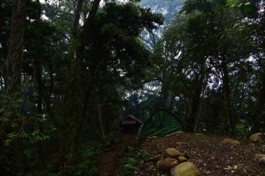
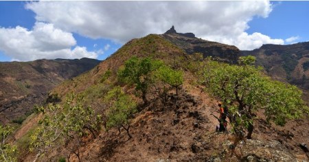
The dry mountains in Uganda are Mt. Moroto ,3083 m, Mt. Kadam, and Mount Mount Murongole. All the three are found in the semi-desert Karamoja region, north-east Uganda along the border with South Sudan and Kenya. They’re the easiest to climb if you come from the flattest countries of the world.
The dry mountains in Uganda are not a continuous chain. Instead, they are a series of volcanic ranges separated by savanna wilderness areas. Mount Murongole is found within Kidepo Valley National Park and Mount Kadam in Pian Upe Wildlife Reserve.
You get to experience authentic rural Ugandan culture. Specifically, the Karamoja is the ultimate rural tourism destination in Uganda. You can visit the Manyatta villages of semi nomadic pastoral communities. Some have been deserted because of the drought on Mount Moroto.
So, choose to combine hiking with visits to local Karamojong villages or game drive safaris in Kidepo or Pian Upe. The number of tourists who travel to Karamoja is relatively small, therefore, gives you an off-the-beaten path Uganda safari experience.
Mount Moroto – a mountaineering adventure off the beaten track
The tallest peak of Mount Moroto 3,083 m (10115 ft). You can hike it in one or two days. No technical experience required. Camping is necessary for 2 days of hiking Mount Moroto. Further, Moroto town provides accommodation for the first overnight visit. For example, Kara-Tunga Safari Camp, Tita tourist resort and Mount Moroto hotel.
Mount Kadam
The elevation of Mount Kadam is 3,063 m and is the second tallest peak in Karamoja region. Reaching the summit takes 2 – 3 days. Day hiking and nature walks are available in addition to game drives in Pian Upe wildlife reserve. Which is home to roan antelopes, cheetahs, white eared kobs, and ostriches.
Mount Morungole
Mount Morungole 2,749 m (9,019 ft) sits on the northern boundary of Kidepo Valley National Park. It is the home of Ik bushmen, the smallest tribe in Uganda. Hiking with a cultural encounter lastsand wildlife viewing in the Narus valley.
Hiking in the Virunga Volcanoes
The Virunga Massif are a continuous chain of 8 volcanic mountains on the border between Uganda, Rwanda and Democratic Republic of Congo. In particular, Mgahinga Gorilla National Park south-west Uganda has Sabinyo, Muhabura and Gahinga volcanoes. All are day hikes requiring no technical experience. They start and end at Ntebeko the headquarters of the park. However, most of the accommodation is found outside the park in Kisoro town which is 15 sq.km (10-minute drive) and 30 min by bike.
Contact us for travel trekking offers